


Things to Know About Bitlis
Bitlis is a city that has been founded on a deep valley and has played an important role as a crossroads throughout history, especially for travelers on the Silk Road. The city has managed to preserve its historical heritage with buildings such as castles, mausoleums, tombs and madrasas. It’s not uncommon to find streets lined with homes dating back to the Palaeolithic Age, while man-made bridges connect different parts of the city.
Throughout history, the region has been home to many civilizations such as the Urartians, Assyrians, Persians, Macedonians, Romans, Seljuks and Ottomans. As a result, the city boasts a rich cultural heritage that is reflected in its architecture, cuisine and traditions.
Located in Eastern Turkey, Bitlis is surrounded by natural beauty, including the Ahlat Tombstones (Ahlat Mezartaşı), which are a Tentative UNESCO World Heritage site, and stunning natural wonders like the Nemrut Volcano (Nemrut Yanardağı) and Nemrut Crater Lake (Nemrut Krater Gölü), as well as the Süphan Mountain (Süphan Dağı). With so much to offer, Bitlis is a must-visit destination for anyone interested in history, culture and nature.
Places to Visit in Bitlis
Ahlat Seljuk Cemetery
Ahlat, situated at the entrance gate to Anatolia and serving as a junction point for the synthesis of east and west, has been an important center for commerce and cultural exchanges for centuries, owing to its significant geographical and historical features.
Throughout its history, Ahlat has been renowned as one of the three major centers of science, culture, and art in the Islamic world, alongside Belh in Afghanistan and Bukhara in Uzbekistan.
The roots of Ahlat’s history can be traced back to the Neolithic ages, around 4000 BC, when the city was first inhabited by the Hurrians. Over the centuries, it came under the rule of various powers until it was ultimately taken over by the Ottomans.
Following the establishment of Turkish rule in 1071, Ahlat became a crucial passage that facilitated the transition from the East to the West. In the 12th century, it served as the capital of the Seljuk branch known as Ahlatshahs.
Ahlat, an ancient city with strategic and historical importance, has been the center of various civilizations throughout history. It has been known as “Khlat” in the Byzantine period, “Khelath” in the Syriac period, and “Rope” during the Arab period. However, its original name “Ahlat” has prevailed over time.
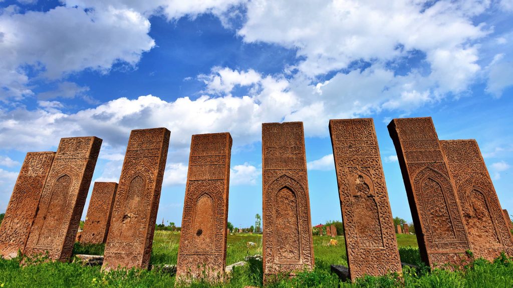
Aside from its natural beauty, Ahlat is also a treasure trove of historical landmarks, including cupolas, bezirhanes, mausoleums, fountains, and cemeteries. One of the most renowned sites in Ahlat is the Seljuk Cemetery.
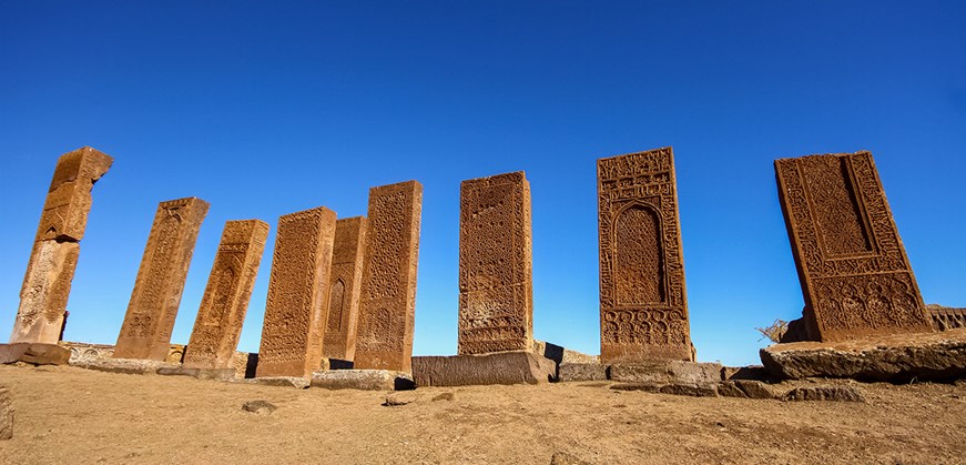
The Seljuk Square Cemetery Ruins are considered the most significant historical cemetery in Ahlat, featuring tombstones and artwork by renowned artists. Covering an area of 210,000 square meters, the Meydan Cemetery is the third-largest Turkish-Islamic cemetery in the world.
Meydan Cemetery in Ahlat is home to three types of graves: Şahideli cist, Sandukali, and Akıt, each designated for a specific group of people such as scientists, artists, religious figures, or craftsmen. The “Kadis Section” of the cemetery is the most significant part, where Kadis have the authority to settle legal disputes and enforce Islamic laws.
Tombstones in Meydan Cemetery bear identity information of the deceased on their east side. Some tombstones also display the deceased person’s profession and place of origin. In addition to the double-headed dragon motifs that reflect Central Asian Turkish culture, the tombstones are adorned with muqarnas decorations and geometric patterns on their west side. Inscriptions on the east side credit the maker of the tombstone and include verses from the Holy Quran. Decorative elements such as palmettes, oil lamps, and textured triangles are also found on the tombstones, creating intricate and detailed patterns.
Bitlis Castle
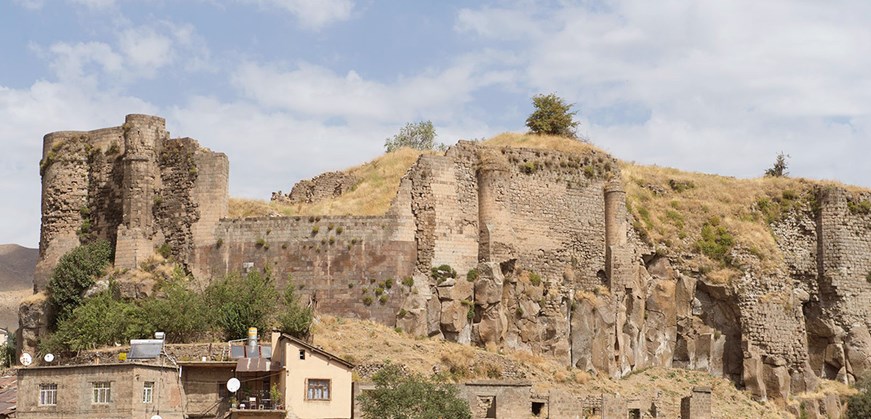
Bitlis Castle was constructed in 312 BC by Badlis, a commander of Alexander the Great, in the city of Bitlis, which is named after the said commander. The castle is an imposing structure with a circumference of 2800 meters and a height of 56 meters. Its 7-meter-thick fortified walls originally encompassed a castle, 300 households, an inn, and a mosque, among other structures. Presently, only the castle remains, with 670 battlements and no defensive ditches surrounding it due to its location on a steep cliff. Restoration work on the castle commenced in 2004 and has been ongoing at regular intervals.
In 641, Bitlis and its castle were conquered by Iyad bin Gane during the reign of Omar bin al-Khattab. Under Seljuk rule, Bitlis became part of the Ottoman lands by the 16th century. During World War One, Bitlis was occupied by the Russians for five months in 1916, but it was reclaimed by the Turkish forces under the command of Mustafa Kemal on August 8th of that same year.
Mount Nemrut & Crater Lake
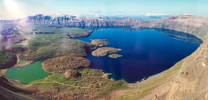
Located in eastern Anatolia, Mount Nemrut & Crater Lake is a towering stratovolcano that is part of the region’s magnificent mountain range. Despite being a dormant, active volcano, the last time it erupted was in 1441. At the top of the volcano lies the Nemrut Lake, which is situated in the crater. Other peaks in the area include Sivritepe (2935 m.), East Nemrut Hill (2625 m.), Tursuktepe (2828 m.) to the south, and Nemrut Mountain Hill (2801m) to the west.
The broad basin of Mount Nemrut is a remarkable sight, with a diameter of up to 6 km and a lake on its western edge. Although it sits at a modest altitude of 2400 meters above sea level, it has a surface area of 10 km2 and a width of 2700 meters from east to west.
The salty lake’s waters are surprisingly sweet. The caldera has steep slopes with a height of 500 meters to 600 meters, with a base level of 2247 meters. In the eastern part of the caldera, there are Obsidian cones that were formed by eruptions after collapses, and the Göl Hill reaches a height of 3485 meters, with Ilıgöl located near the north end. The lake has a circular shape with a diameter of approximately 500 meters and a maximum depth of 10 meters. Like Lake Nemrut, it also has fresh water. Large areas at the footsides of the volcano’s feetsides are occupied by lava and tuff plateaus.
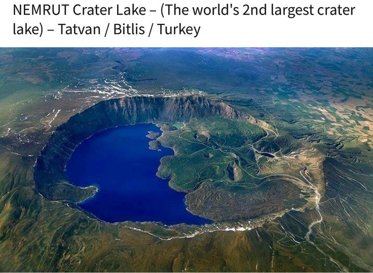
Mount Nemrut, located in eastern Anatolia, is a volcanic mountain featuring numerous lakes, lava outlets, and other volcanic formations within its caldera. The mountain is a dormant, active volcano, and its last eruption occurred in 1441. Its crater houses Lake Nemrut, which is crescent-shaped and covers approximately 15 km², with an elevation of 2247 meters above sea level. This is 600 meters higher than Lake Van, another large lake in the region.
The volcanic material in the area includes slag, pumice, and obsidian. The rocks in the region are composed of basalt, andesite, trachyte, and other types of volcanic materials, such as ash, tuff, pumice, and ignimbrite.
Within the caldera of Mount Nemrut, there are five lakes, six caves, and various volcanic formations such as lava outlets, lava funnels, and splash cones. The hot spring of Mount Nemrut, located in the crater, has a temperature of 60 degrees Celsius and is believed to cure rheumatism and skin diseases, although it currently lacks facilities for visitors.
El Aman Caravanserai
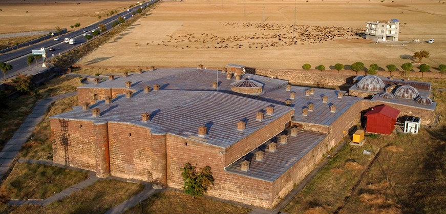
Located in the Bitlis region’s Amble Plain, El Aman Caravanserai was constructed during the Ottoman era by Van Beylerbeyi Hüsrev Pasha in the 16th century. This historic inn is situated on the Silk Road, an ancient trade route that facilitated the exchange of goods, ideas, and people between the East and West. El Aman Caravanserai is a vast structure that served travelers with food, water, and shelter for centuries. It features a winter room, bread ovens, and stables to protect animals from the cold weather.
The exact date of the construction of this caravanserai is unclear as there are no inscriptions indicating when it was built. However, it is believed to have been constructed in the 16th century in the Rahva plain where the Bitlis-Muş and Van roads meet. This location was particularly treacherous for caravans during the winter due to the nearby winding mountain pass. Initially, the caravanserai was likely intended as a shelter for travelers, but over time, it grew into a larger complex with a focus on practicality.
The caravanserai consists of five sections: a courtyard, a mosque, a bathhouse, a pool, and 160 rooms. Made of black stone from solid veins, it is an impressive 90 meters long and 70 meters wide with a rich history that spans over 600 years. After several additions, the caravanserai has become the largest of its kind in Anatolia in terms of the area it covers.
Serefiye Mosque
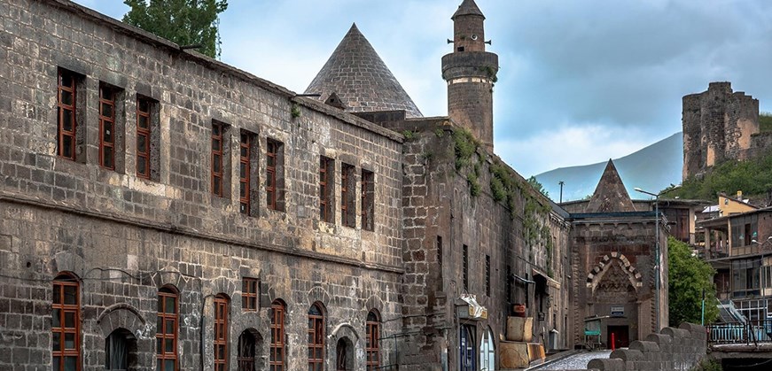
The Serefiye Mosque complex, situated south of the city center, is comprised of a mosque, a madrasa, a kitchen, and a tomb. It was constructed by Serefhan IV in 1529, as indicated by its inscription.
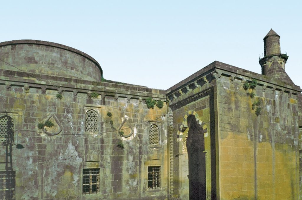
Constructed with meticulously cut stone materials, the Serefiye Mosque stands out with its five-section narthex and transverse rectangular harim. The north doors on the facade lead into the harim, and are shifted to two corners. The inside of the mosque is domed and has three transverse naves.
The dome situated in front of the mihrab intersects with each of the four other naves, and spans between them on all sides but one. The first nave located on the qibla side is covered by a dome at its corners while barrel vaults span between them. The second, wider nave covers more ground, with barrel vaults set at different heights. Barrel vaults also run through the spaces between them to cover a third nave, even though only two have domes that span from corner to corner.
The Serefiye Mosque complex, built in 1529 by Serefhan IV, is located in the southern part of the city center. The complex is comprised of several buildings, including a mosque, a madrasa, a kitchen, and a tomb.
The mosque is constructed of smooth-cut stone materials and features a five-section narthex and a rectangular harim with three transverse naves. The dome in front of the mihrab is slightly rounded and made of bricks on the inside, with a high cylindrical drum that is flattened on the outside. The sanctuary’s roof and its last assembly area are treated as a flat roof.
The mihrab is rectangular with a semicircular plan and features Arabic inscriptions reading “Kavsara” and “ma’kil” at the top. The doors are plain rectangular openings with carved half-rose bezek at two corners, and there are rich floral ornaments on the body and capital of the pillars as well as on the lintel. A pointed arch opening on the east side displays openwork geometric patterns inside it. The piers, arches, and walls are smooth-cut stone, while the floors and ceilings are plastered. The wood now covers half of the main walls. The mihrab niche has a hemispherical plastered top, and the pulpit is made of wood and is not original. The pulpit is decorated with various religious and geometric patterns carved into it.